Файл:Upper Terraces of Mammoth Hot Springs.jpg
Перейти к навигации
Перейти к поиску


Размер этого предпросмотра: 800 × 569 пкс. Другие разрешения: 320 × 228 пкс | 640 × 455 пкс | 1024 × 728 пкс | 1280 × 910 пкс | 2100 × 1493 пкс.
Исходный файл (2100 × 1493 пкс, размер файла: 2,17 Мб, MIME-тип: image/jpeg)
|

Краткое описание
| Описание |
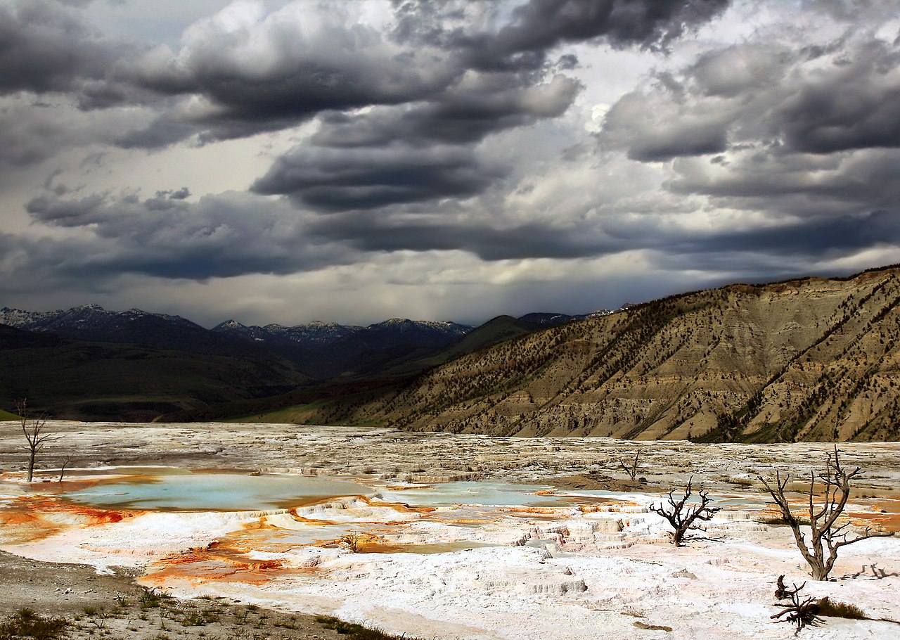
English: Hot water is the creative force of the terraces. Even though Mammoth Hot Springs lie north of the caldera ring-fracture system, a fault trending north from Norris Geyser Basin, 21 miles (34 km) away, may connect Mammoth Hot Springs to the hot water of that system. A system of small fissures carries water upward to create approximately 50 hot springs in the Mammoth Hot Springs area. Another necessary ingredient for terrace growth is the mineral calcium carbonate. Thick layers of sedimentary limestone, deposited millions of years ago by vast seas, lie beneath the Mammoth area. As ground water seeps slowly downward and laterally, it comes in contact with hot gases charged with carbon dioxide rising from the magma chamber. Some carbon dioxide is readily dissolved in the hot water to form a weak carbonic acid solution. This hot, acidic solution dissolves great quantities of limestone as it works up through the rock layers to the surface hot springs. Once exposed to the open air, some of the carbon dioxide escapes from solution. As this happens, limestone can no longer remain in solution. A solid mineral reforms and is deposited as the travertine that forms the terraces. (The image caption was taken from here.)
Français : Hautes terrasses de Mammoth Hot Springs (Litt. « Les sources chaudes taille mammouth ». Les terrasses (ou plutôt les gours) de Mammoth hot springs ont une origine géologique assez complexe: Le site de Mammoth hot springs ne se trouve pas dans la Caldeira de Yellowstone, mais sur un substrat sédimentaire Calcaire. De l'eau chaude provenant du bassin de Norris situé à 34 km de là circule vers cette zone via un système de failles orientées nord-sud. Cette eau est chargée en Acide carbonique, ce qui lui confère la propriété de dissoudre le calcaire. Lorsque l'eau chaude chargée en calcaire émerge, une partie de l'acide carbonique s'évapore sous forme de dioxyde de carbone, et une partie du calcaire précipite, formant de gigantesques gours. |
| Источник | Собственная работа |
| Автор | Brocken Inaglory |
| Местоположение камеры | | Это и другие изображения по их местоположению на OpenStreetMap |
|---|
Лицензирование
Я, владелец авторских прав на это произведение, добровольно публикую его на условиях следующих лицензий:
Этот файл доступен по лицензии Creative Commons Attribution-Share Alike 3.0 Unported.
- Вы можете свободно:
- делиться произведением – копировать, распространять и передавать данное произведение
- создавать производные – переделывать данное произведение
- При соблюдении следующих условий:
- атрибуция – Вы должны указать авторство, предоставить ссылку на лицензию и указать, внёс ли автор какие-либо изменения. Это можно сделать любым разумным способом, но не создавая впечатление, что лицензиат поддерживает вас или использование вами данного произведения.
- распространение на тех же условиях – Если вы изменяете, преобразуете или создаёте иное произведение на основе данного, то обязаны использовать лицензию исходного произведения или лицензию, совместимую с исходной.

|
Разрешается копировать, распространять и/или изменять этот документ в соответствии с условиями GNU Free Documentation License версии 1.2 или более поздней, опубликованной Фондом свободного программного обеспечения, без неизменяемых разделов, без текстов, помещаемых на первой и последней обложке. Копия лицензии включена в раздел, озаглавленный GNU Free Documentation License. |
Вы можете выбрать любую из этих лицензий.
История файла
Нажмите на дату/время, чтобы увидеть версию файла от того времени.
| Дата/время | Миниатюра | Размеры | Участник | Примечание | |
|---|---|---|---|---|---|
| текущий | 04:08, 5 апреля 2009 | | 2100 × 1493 (2,17 Мб) | wikimediacommons>Mbz1 | improved quality |
Использование файла
Нет страниц, использующих этот файл.