Файл:Satellite image of France in August 2002.jpg
Перейти к навигации
Перейти к поиску


Размер этого предпросмотра: 780 × 600 пкс. Другие разрешения: 312 × 240 пкс | 624 × 480 пкс | 999 × 768 пкс | 1280 × 985 пкс | 2560 × 1969 пкс | 5200 × 4000 пкс.
Исходный файл (5200 × 4000 пкс, размер файла: 3,75 Мб, MIME-тип: image/jpeg)
| Описание |
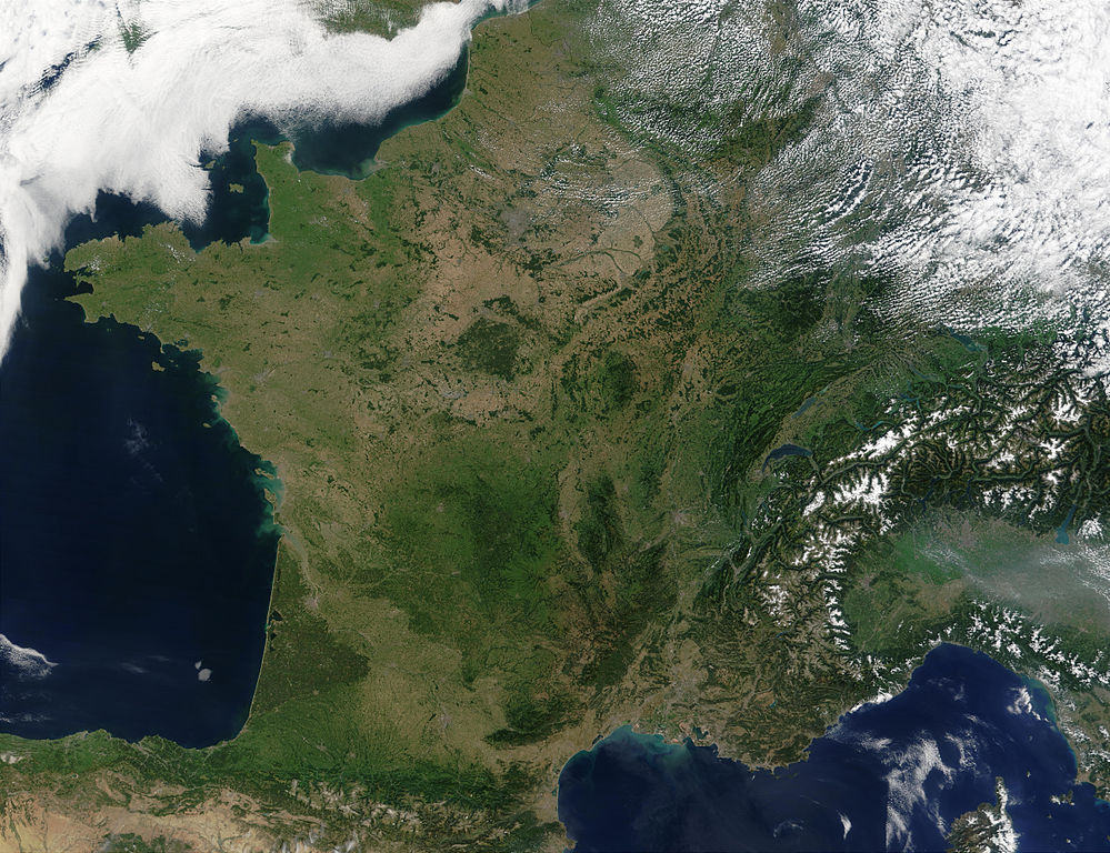
English: Satellite image of France acquired August 14, 2002, by the Terra satellite.
Suomi: Satelliittikuva Ranskasta elokuussa 2002 |
| Дата | |
| Источник |
Slightly cropped image. Original taken from NASA's Visible Earth: [1]. Credit: Jacques Descloitres, MODIS Rapid Response Team, NASA/GSFC |
| Автор | Jacques Descloitres, MODIS Rapid Response Team, NASA/GSFC |
| Этот файл находится в общественном достоянии (англ. public domain), так как он был создан NASA (Национальным управлением по аэронавтике и исследованию космического пространства). Политика авторского права NASA гласит, что «Материал NASA не защищается авторским правом, если не указано иное». (См. Template:PD-USGov, страницу политики авторского права NASA или политику использования изображений JPL.) | ||
 |
Предупреждения:
|
Эта иллюстрация выбрана изображением дня для 4 мая 2005 года. У неё следующее описание: Русский: Франция из космоса Другие языки
Ænglisc: Francland gesewen of woruldrúme Bân-lâm-gú: Tùi thài-khong khoàⁿ Hoat-kok. Català: França des de l'espai. Čeština: Francie při pohledu z vesmíru Cymraeg: Frainc o'r gofod. Deutsch: Frankreich aus dem Weltraum gesehen English: France from space Français : La France vue de l'espace. Galego: Francia Italiano: La Francia vista dal satellite. Nederlands: Frankrijk vanuit de ruimte. Norsk bokmål: Frankrike fra rommet Polski: Francja z kosmosu Slovenčina: Francúzsko pri pohľade z vesmíru Suomi: Elokuinen manner-Ranska satelliittikuvassa Svenska: Satellitbild på Frankrike Беларуская: Францыя з космасу Български: Франция от космоса Русский: Франция из космоса ไทย: ประเทศฝรั่งเศสเมื่อมองจากอวกาศ 한국어: 우주에서 바라본 프랑스 日本語: 宇宙から見たフランス 中文: 法国卫星照片 |
История файла
Нажмите на дату/время, чтобы увидеть версию файла от того времени.
| Дата/время | Миниатюра | Размеры | Участник | Примечание | |
|---|---|---|---|---|---|
| текущий | 12:50, 15 января 2008 | | 5200 × 4000 (3,75 Мб) | wikimediacommons>Kyle the hacker | uncropped, better definited version |
Использование файла
Следующая страница использует этот файл: