Файл:Glacial lakes, Bhutan.jpg

Исходный файл (3000 × 1665 пкс, размер файла: 1,98 Мб, MIME-тип: image/jpeg)
|

Эта иллюстрация выбрана изображением дня для 21 марта 2007 года. У неё следующее описание: Другие языки
Қазақша: Хималайя арқаларындағы мұздықтар мен көлдер, Бутан |
Краткое описание
| Описание |
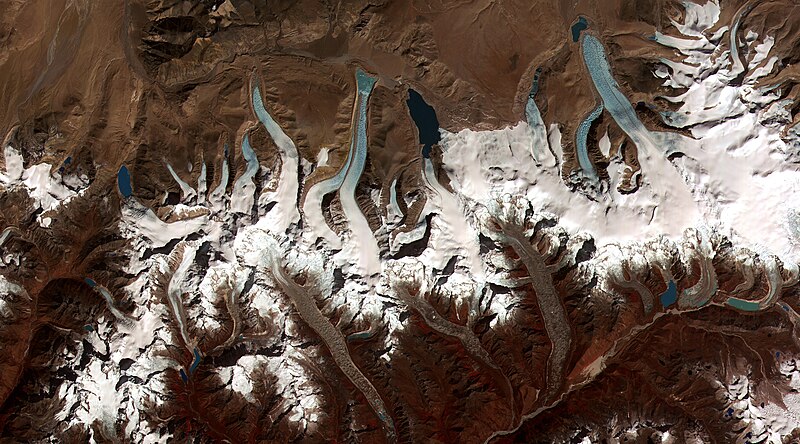
English: This image shows the termini of the glaciers in the Bhutan-Himalaya. Glacial lakes have been rapidly forming on the surface of the debris-covered glaciers in this region during the last few decades. USGS researchers have found a strong correlation between increasing temperatures and glacial retreat in this region. According to a joint press release issued by NASA and the U.S. Geological Survey, the great majority of the world’s glaciers appear to be declining at rates equal to or greater than long-established trends. This image from the ASTER (Advanced Spaceborne Thermal Emission and Reflection Radiometer) instrument aboard NASA’s Terra satellite shows the termini of the glaciers in the Bhutan-Himalaya. Glacial lakes have been rapidly forming on the surface of the debris-covered glaciers in this region during the last few decades. Français : Image de l'instrument ASTER (Advanced Spaceborne Thermal Emission and Reflection Radiometer) embarqué à bord du satellite Terra de la NASA montrant l'extrémité des glaciers hymalayens du Bhoutan.
Depuis quelques décennies, des lacs glaciaires se forment rapidement sur la surface couverte de débris de ces glaciers. Les scientifiques de l'USGS (United States Geological Survey) ont montré une forte corrélation entre la montée des températures et le retrait des glaciers dans la région. En Himalaya, les glaciers reculent a une vitesse alarmante et de plus en plus importante, ce qui est établi par la comparaison des données actuelles et historiques, ainsi que par la multiplication et la croissance rapide des lacs de surface de ces glaciers, selon Jeffrey Kargel, de l'USGS. |
|||||
| Дата | Data acquired on June 4, 2002, image released on June 8, 2006. | |||||
| Источник | http://visibleearth.nasa.gov/view_rec.php?id=2876 | |||||
| Автор | NASA | |||||
| Права (Повторное использование этого файла) |
|

| Местоположение камеры | | Это и другие изображения по их местоположению на OpenStreetMap |
|---|
История файла
Нажмите на дату/время, чтобы увидеть версию файла от того времени.
| Дата/время | Миниатюра | Размеры | Участник | Примечание | |
|---|---|---|---|---|---|
| текущий | 00:19, 14 февраля 2006 | | 3000 × 1665 (1,98 Мб) | wikimediacommons>Brian0918 | larger version |
Использование файла
Нет страниц, использующих этот файл.